Steiglitz EL6164 (100% New Hanover Exploration)
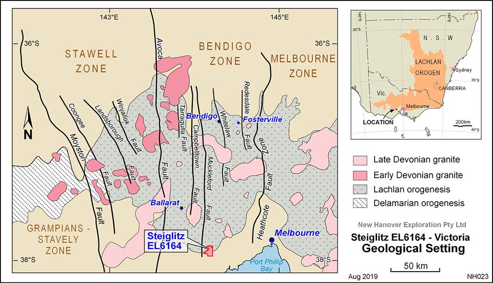
The Steiglitz goldfield in Victoria is the main area of interest for New Hanover Exploration.
The Steiglitz Goldfield produced around 250,000 ounces of gold at a grade of 38 grams of gold per tonne ranking it in the top 10 of producers and the second highest grade in the Bendigo gold belt.
Exploration Licence (EL) 6164 covers approximately 51 square kilometres over the southern part of the Steiglitz Goldfield current to 12 October 2026.

Geology
The Steiglitz Goldfield is defined by a series of parallel workings within an area measuring 8 km long and 1.6 km wide. Ordovician (444 to 485 million years) rocks are folded into series of anticlines and synclines. The Ordovician rocks comprise fossiliferous (graptolite) carbonaceous slate, fine grained micaceous sandstone, coarse-grained sandstone, shale and mudstone.
The Hanover Fault is a major regional fault trending NE across the dominant structural grain of the Ordovician rocks. The north dipping fault was originally recognised by Ferguson’s mapping in 1907, (published 1940). Subsequent biostratigraphy using graptolite zonation (Harris and Thomas, 1948) showed that the fault is a high angle thrust separating older Lower Ordovician rocks to the north from younger Middle Ordovician rocks to the south.
The Hanover Fault does not have any obvious physiographic expression and is marked in outcrop by a broad zone of sheared and brecciated sandstone and slate. Mineralisation along the fault is reflected by scattered quartz float at surface and old workings.
Younger Tertiary (5-34 million years) rocks include two phases of basalt and marine and non-marine sands and gravel, known as the ‘Steiglitz Sands and Gravels’. The more quartz rich gravels are currently excavated for industrial use. Much younger Quaternary (0.01- 2.6 million years) sediments also crop out in the south of the licence area.
Gold Mineralisation
All historic gold production is from the hinge zone of the Steiglitz Anticlinorium near Steiglitz Township, the Hanover Fault zone and the Sailors Mine to the south of the Hanover Fault.
Production came from two types of lode – both of which are of interest to New Hanover Exploration.
1. The first type is best described as typical high grade slate belt gold mineralisation and comprises quartz-rich veins, typically less than one metre thick that strike mostly parallel to the north-south axial plane of the Steiglitz Anticlinorium. These gold-bearing veins also contain subordinate carbonate minerals and minor sulfide minerals including pyrite, arsenopyrite, sphalerite, galena, chalcopyrite, bournonite and tetrahedrite. Saddle reefs and inverted saddle reefs and other lodes which occupy faults and cross-cut bedding were also mined by the old timers.
2. The second type of lode consists of quartz vein stockwork mineralisation 3-4 metres in width within and parallel to zones of shearing in the Hanover Fault. This style of mineralisation was mined historically at Hanover, Garlic, New Mariners and Mount Pleasant. Gold was reportedly fine-grained and silver-rich at the Hanover Mine, with the ore containing “a large proportion of antimony”. A broad envelope of shearing associated with the New Hanover fault has been mapped over five kilometres. Historical records at Hanover No. 3 reveal assays of up to 12.6 grams over 3.4 metres; and reconnaissance core drilling has recorded 47 metres grading 0.41 grams of gold per tonne, including 2 metres at 1.95 grams of gold per tonne.
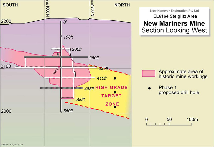
A variation of types 1 and 2 mineralisation has been recognized by New Hanover Exploration. This occurs where the mineralized New Hanover fault intersects the north-south trending lode gold. The effect of this intersection is to produce mineralization with characteristics of both the high grade slate belt style and shear-hosted style. A good example of this hybrid style is at New Mariners, one the one main producers in the gold field, where grades of more than 30 grams of gold per tonne were mined in association with antimony and arsenic sulfides from zones three to four metres in width. The Company considers New Mariners has potential to host bonanza grade gold like Fosterville.

A cross section of New Mariners looking west

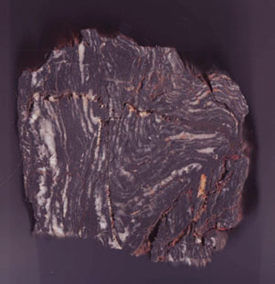
Mineralised quartz-rock from Hanover Fault
(specimen approx. 25cm across)
Modern Age Dating of Hanover Fault
Based on graptolite assemblages and field mapping, the age of the Hanover Fault has been estimated to be around Middle Devonian or roughly 390 million years old. However, no modern geochronological studies had been undertaken to more accurately estimate the age of the fault and associated mineralisation. Using core from a legacy hole DD09STG004 that intersected gold mineralisation in the Hanover Fault, a geochronological study was initiated by the Company in collaboration with the world-leading John de Laeter Centre at Curtin University, Western Australia.
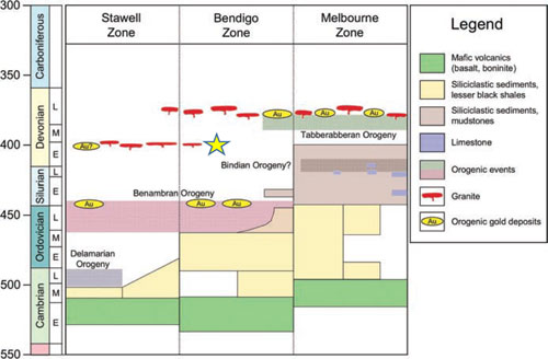
The results of the in situ analysis (laser oblation) of mica using a strontium-rubidium technique revealed a robust age of 405Ma ±6Ma (Ma is an abbreviation for millions of years). This is shown as a yellow star in the following figure. It is younger than the 440Ma old slate belt gold mineralisation in the Bendigo Zone, as exemplified in the north-south trending mineralisation at Steiglitz but older than the previously estimated age of 390 Ma. This age, however, is close to a reported age for gold mineralisation in the Stawell Zone, west of Bendigo and represents one of the first, younger ages of mineralisation in the Bendigo Zone. The result suggests the gold mineralisation associated with the Hanover Fault may be associated with a granite magmatic event, as shown in the following figure.

Age dating of mica associated with mineralised Hanover Fault, Yellow star 405Ma ±6Ma.
(Modified from Phillips et al. (2012) and VandenBerg et al. (2000)).
Proposed Work Program
New Hanover Exploration’s work program includes continuing literature review and digitisation of archival maps, geological mapping, rock chip sampling, soil sampling, possible geophysical surveys, shallow auger drilling, reverse circulation drilling and core drilling.